Or not.
These are the 5 main stages (no prologue)...and they are not in order. Another disclaimer: these loops do not appear to be very long. But because of altitude and the fact that there's very little road to be had here, they are as big around as a can of corn.
Guyot Loop: 39.35 miles/8561'


Colorado Trail Loop: 34.38 miles/7811'


Wheeler Loop: 35.91 miles'/7620' 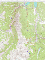


Pennsylvania Creek Loop: 28.08 miles/5993'


Gold Dust Loop: 33.18 miles/5496'


5 comments:
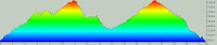
o on the wheeler loop are we just lemming it?
It's more like Evel Knievel. Make sure you bring your white pantsuit.
wheeler profile not link on blogspot. all other profiles are linked. is there a fix?
thx.
Should be fixed now - check it out. We may add anouther climb to the Wheeler loop at the suggestion of a few locals and their times practicing the route ovet the last few years. The climb up to the pass is a slog, but there's some really fast stuff on the backside and the finish on Peaks is a middle-to-big-ring grinfest.
MM
oh, yep the race definitely need another climb or two.........what is wrong with you?
Post a Comment